


War at Sea (Hardback)
A Naval Atlas 1939-1945

(click here for international delivery rates)
Need a currency converter? Check XE.com for live rates
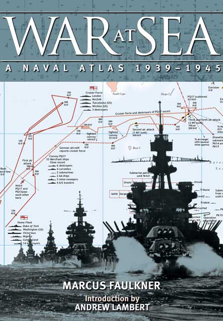
In the vast literature of the Second World War there has never been a naval atlas showing graphically the complexities of the war at sea, a war which spread across every ocean. This new book will fill the gap.
With more than 200 beautifully-designed maps and charts, the atlas sets out to visualise the great campaigns and major battles as well as the smaller operations, amphibious landings, convoys, sieges, skirmishes and sinkings. While whole sections are given over to the Pacific war, the battle of the Atlantic and the campaigns in the Mediterranean, smaller but crucial events such as the landings at Dieppe receive in-depth treatment. The maps depict the dynamics of campaigns and battles but also include extensive information on the opposing forces, their ships and equipment and the strategic significance of events. General thematic maps, for instance, on ship losses, aerial strengths or convoy routes, give the reader an understanding of the many contributing factors that shaped the tactics and strategies of the Allied and Axis forces.
No other work has attempted such an ambitious coverage of the war at sea in this period and it is destined to become a definitive reference work for naval enthusiasts and historians as well as general readers fascinated by the naval war that extended from the coldest arctic seas to the tropical islands of the Pacific.
Register or Login now to post a review!
This is a really interesting and indispensable work for all enthusiasts and students, available - besides - at a very interesting price: a factor that, combined with an undoubted quality and a very elegant graphic design, suggests the purchase the book to all those wishing to deepen the operational (and cartographic) aspects of the naval events of the Second World War.
STORIA militare, March 2019
As a graphic device, charts/maps are the very embodiment of the adage that a picture is worth a thousand words. It should be noted, though, that the type of sea chart used in books such as this is not topographical because depth has no immediate impact on surface action. This aspect does come into play in real life (and not just when submarines are involved!) so the really curious reader will have to do some digging elsewhere.
Speed Readers
Everything you may have picked up from reading texts about naval engagements will come into sharper focus—if not an entirely new understanding—thanks to Faulkner’s book/s.
Read the full review here!
Consists of large, clear, full-colour maps accompanied by tables of forces and losses, and Marcus Faulkner's concise text entries describing the background and progress of the events depicted. The large format of the book helps enormously, and care has been taken in most cases to make sure that as little detail as possible is lost in the 'gutter' between the pages. The clarity of the illustrations also serves to highlight some striking - and on occasion surprising - patterns.
Warship Annual
The War at Sea: A Naval Atlas, 1939-1945 is not only an information tour de force but its bright and crisp colour maps make it very pleasing to the eye (and the brain). Faulkner has produced a reflective piece of serious scholarship that is both extremely useful and a visual delight. It will be a welcome addition to the libraries of amateurs and scholars alike.
International Journal of Maritime History
A significant new book [that] will have a place in any reference setting where the course of the Second World War is either studied in depth or is a matter of serious interest.
Reference Reviews
A well – balanced, extensive examination of the major and minor occurrences of the naval portion of World War II. The author presents the material in a concise, easy to read format, and the wealth of visual information and accompanying explanations, complemented by the use of colour, symbols, and a glossary of terms and abbreviations, allow even a lay reader to follow and understand the text. The complementary organisation and thorough account for primary and secondary source material make this a must have reference for scholars and armchair historians alike.
Nautical Research Journal
Naval operations in World War Two began on the first day of the conflict and continued until the September 3, 1945, surrender ceremony on the battleship USS Missouri (BB-63). These operations were a complex series that interconnected in a way that land an air battles seldom approached. Since maps can convey both space and time in an understandable fashion, an atlas is a very good way to tell the history of the war at sea
Warships International
between September 1939 and September 1945. The maps in this volume are areranged chronologically so it can be read as a history of the naval war. But each indivdual map is self-contained, so any map can be used as a reference to the particular operation it covers.
The maps are in color, which allows color-coding of different forces for easy identification. There is a block of text with each map that provides details relevant to the map, and a full-page table explaning the symbols and abbreviations used throughout the book. Some are specific to
the ships of a particular navy and there are generic symbols for ships such as escort carriers, landing ships and merchatmen in general. The maps themselves vary in coverage. For example, the very first map shows the different British Navy stations worldwide at the start of the war along with the types and numbers of ships assigned to each. There are similar maps for the French Navy, German Navy, Italian Navy and a map that covers the ships in British home waters in late 1939. Individual battles are covered with one or several maps from the Battle of the River Plate (one map) to the
German invasion of Norway (6 maps).
Additional maps showing strength and locations of the naval forces of Italy, Japan and the United States are provided when the chronology reaches those countries' date of entry in the war. Also, many battles and operations are included that don't always get much attention, such as the 6 March 1943 battle in Blackett Strait in the Solomon Islands. Throughout this book details have been carefully checked with post-war research to provide as accurate a picture of the events described as possible. However,
on page 185 there is an error both in the text and on the map when it is said the U. S. destroyers Dunlap (DD-384), Craven (DD-382) and Maury (DD-401) launched thirty-six torpedos in one salvo at a force of four Japanese destroyers. In fact, those three U. S. destroyers could only launch a total of twenty-four torpedos in one direction at one time.
The fact that the pages are nine inches by twelve and a half inches lets the maps and texts be an easily-readable size, and the coverage is so extensive that every serious student of World War Two at sea will find this a highly useful book to have. It is packed with information in an easy to
use format, and is well worth the purchase price.
This unique and outstanding naval atlas of the Second World War is a magnificent book providing excellent coverage of the war at sea over that period. If a picture is worth a thousand words then these detailed maps must be quite an order of magnitude greater.
Scuttlebutt - Autumn Edition
The book is sumptuously produced and will become an essential reference book in all naval libraries. I do hope this may set a trend for more such high quality naval and military atlases. Most highly recommended for both the historian and the general reader alike.
Henceforth, no-one contemplating writing about a naval action in the 20th Century's second global conflagration should do so without referring to this atlas. Each full-colour map is accompanied by short, insightful text and an overview of the order of battle. What's impressive about this tome – beyond the crystal clear graphics – is that it's not RN-cenric, or even USN-centric. Its scope is global – and it features some pretty obscure actions/operations.
Navy News
Perhaps the standout map is that for Operation Chariot, the St Nazaire raid showing the track not just of HMS Campbeltown which charged the gates of the Normandie dock, but also the flotilla of gun and torpedo boats accompanying her. In a word: outstanding.
A mammoth undertaking. Within its 275 pages author Marcus Faulkner covers most of the naval engagements of the Second World War, as well as amphibious landings, convoys, sieges, skirmishes and sinking’s with detailed color maps and a brief narrative within each entry. Naval historian Andrew Lambert introduces the atlas with a lengthy essay on the impact of sea power prior to and during World War II and suggests that “for all of the fighting on land, the extensive bombing objectives, and even the use of atomic weapons in 1945, the outcome of the Second World War was settled by allied control of global oceanic communications.” With that said Faulkner states in the preface that “this book can be used in two different ways.” Because the atlas is organized mostly chronological it can serve as a naval history of the Second World War, or it can be used as a reference to individual campaigns or battles. In most cases the major operations and battles like the Aleutians or the Battle of the Philippine Sea are allotted two pages while less significant battles such Operation Harpoon or Kula Gulf are described in one page. A key to the maps for the battles and operations is provided that show the progress and courses of the task forces and squadrons, along with an order of battle and ship losses and air power. Appropriately, significant sections of the atlas cover the Pacific Theater while the Battle of the Atlantic and operations in the Mediterranean receive adequate treatment as well. Each section is organized by year and introduced with a short overview and map of the world that shows where each of the major battles, operations and convoy routes took place. Faulkner thoughtfully includes the page number on the maps so readers know where immediately where to look for the relevant coverage of the events for that year. The atlas concludes with an extensive bibliography of primary sources, official histories and secondary sources. Even though operations led by the United States Navy make up a considerable portion of the atlas from 1942 onward, there is no evidence that Faulkner conducted research at American archival repositories. The index is useful only if you want to search by battle, convoy, operation, groups or vessel because none of the commanders are cited. War at Sea is a valuable and highly recommended reference source. Although the steep price of almost $89.00 may limit purchase to only die-hard naval and World War II historians, it is a must acquisition for research libraries.
Dr. Yockelson, a professor at the United States Naval Academy
Altogether this makes for fascinating reading. Not all at once—that’s not the purpose. But as a reference book, to be opened and looked at, event by event, or as a reference tool—for those text volumes that have provided inadequate illustrative maps. The maps are easy to interpret, even for highly complicated actions such as Operation Vigorous of RAdm Vian’s force against the Italian battleships in June 1942, or more general long term operations, such as a chart for “German E-Boat Attacks 1940-1945” (in the Channel, p.141), the latter including a box of “Approximate Strength of S-Boat Force” by half-yearly periods. Apart from the operational maps themselves, these small added details make the volume a most valuable addition to any bookshelf—or coffee table.
Starshell - Naval Association of Canada
After I opened the packaging in which my review copy arrived, it only took me a few minutes to realise that this is an important book. The Publisher's letter which accompanied it described it as 'unsurpassed' and 'unique' and it fully justifies both those adjectives; I would add a third, 'outstanding'.
Journal of the Australian Naval Institute
I believe that it is worth its high 'price tag' and will be a most important addition to the book collection of anyone with an interest in naval history. I recommend it highly.
'War at Sea: A Naval Atlas 1939-1945' is sure to become a classic. Created by Marcus Faulkner, with an introduction by Andrew Lambert, we discover that a picture (or rather a battle map) is worth a thousand words.
Warships International Fleet Review - Nov 2012
Faulkner's text is brief and crisp and Andrew Lambert's introduction is a peerless piece of prose. Peter Wilkinson, who designed and drew the charts and diagrams, deserves a great deal of praise for his excellent work. It all makes for a magnificent book that is well deserving of the highest praise for its execution and presentation.
By the very nature of naval actions, spread over extended geographical areas as they often were, it is sometimes difficult to gain a full understanding of events without referring to a map. This is where this book, produced in the high-quality, large-scale format that we have come to expect from Seaforth, excels. With more than 225 specially created maps and detailed charts, all of which have been produced to a remarkably high standard, this atlas is a must for anyone with an interest in the naval and maritime aspects of the Second World War.
Britain at War Magazine

Pen and Sword Books
About Us | Contact Us | Delivery Information | Privacy Policy | Cookies | Affiliates | Terms and Conditions | Backlist | Mailing List | Reward Scheme | Review Request
© Pen and Sword Books Limited 2026. Registered in England No. 2527258.
Registered Office: 47 Church Street, Barnsley, S70 2AS.