


From Blackfriars to Bankside (Hardback)
Medieval and later riverfront archaeology along the route of Thameslink, central London
Imprint: OAPCA
Series: Thameslink Archaeological Series
Pages: 134
Illustrations: 60 illus.' 19 tables
ISBN: 9780995663602
Published: 20th December 2016
 Script Academic & Professional
Series: Thameslink Archaeological Series
Pages: 134
Illustrations: 60 illus.' 19 tables
ISBN: 9780995663602
Published: 20th December 2016
You'll be £5.95 closer to your next £10.00 credit when you purchase From Blackfriars to Bankside. What's this?
+£4.99 UK Delivery or free UK delivery if order is over £40
(click here for international delivery rates)
Order within the next 11 hours, 5 minutes to get your order processed the next working day!
Need a currency converter? Check XE.com for live rates
(click here for international delivery rates)
Order within the next 11 hours, 5 minutes to get your order processed the next working day!
Need a currency converter? Check XE.com for live rates
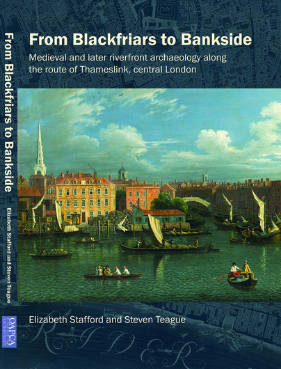
The Thameslink project involved the construction of new commuter stations on both banks of the Thames, the first to span the river and the first new station to be built in the area for 120 years. Fieldwork undertaken by Museum of London Archaeology (MOLA) involved drilling and monitoring of geotechnical boreholes and trial pits, and excavation on the north bank. A sedimentary deposit model spanning the Thames channel was constructed using the geoarchaeological evidence. Traces of Roman activity at the confluence of the Thames and Fleet suggested there was a dock here during this period. Radiocarbon dates from deposits on the south bank attested to Middle Saxon and later activity, and environmental remains demonstrated the tidal nature of the river, with freshwater and saltmarsh present within a mixed landscape of woodland, farming, and land reclamation from early medieval times. The footings of an important 14th-century precinct wall associated with Blackfriars Friary were constructed on Roman foreshore gravels, and remains of other medieval structures included a timber jetty or waterman’s stairs. Later waterfront structures included a possible dock or wharf that resembled 17th- century examples found elsewhere in London. A riverside wall constructed after the Great Fire was supported on reused timbers taken from a demolished high status building, dated by dendrochronology to 1593–1627. Reconstruction mapping provided details of the Blackfriars area from the 13th–17th centuries, after which point historic maps allowed the structures to be placed in the context of historic London.
Other titles in the series...

Other titles in OAPCA...
Pen and Sword Books
About Us | Contact Us | Delivery Information | Privacy Policy | Cookies | Affiliates | Terms and Conditions | Backlist | Mailing List | Reward Scheme | Review Request
© Pen and Sword Books Limited 2025. Registered in England No. 2527258.
Registered Office: 47 Church Street, Barnsley, S70 2AS.