


Google Books previews are unavailable because you have chosen to turn off third party cookies for enhanced content. Visit our cookies page to review your cookie settings.
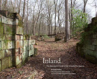
Inland (Hardback)
The Abandoned Canals of the Schuylkill Navigation
You'll be £32.00 closer to your next £10.00 credit when you purchase Inland. What's this?
+£4.99 UK Delivery or free UK delivery if order is over £40
(click here for international delivery rates)
Order within the next 8 hours, 12 minutes to get your order processed the next working day!
Need a currency converter? Check XE.com for live rates
(click here for international delivery rates)
Order within the next 8 hours, 12 minutes to get your order processed the next working day!
Need a currency converter? Check XE.com for live rates
The Schuylkill River flows more than 100 miles from the mountains of the Pennsylvania Coal Region to the Delaware River. It passes through five counties - Schuylkill, Berks, Chester, Montgomery, and Philadelphia - and its valley is home to more than three million people, yet few are aware of the hidden ruins and traces left by a pioneering 200-year-old inland waterway: the Schuylkill Navigation. Some of it is literally buried in their own backyards.
Often called the Schuylkill Canal, this complex Navigation system actually boasted twenty-seven canals. The first of the anthracite-carrying routes in America, the 108-mile Navigation shadowed the Schuylkill River for nearly all its length. It once had more than thirty dams and slackwater pools, more than 100 stone locks, numerous aqueducts, and the first transportation tunnel in the nation. They were all built by hand starting in 1816.
In the 1940s, as part of a massive environmental cleanup of the river, this important and influential infrastructure was largely dismantled - but not entirely. Two short sections of the watered canal get plenty of attention: the Oakes Reach at Schuylkill Canal Park near Phoenixville and the Manayunk Canal in Philadelphia. Both are popular recreational destinations. What happened to the rest of it?
Photographer Sandy Sorlien resolved to find out. Over the course of seven years, she traveled upriver repeatedly to bushwhack along the riverbanks and to row and paddle in the river itself. Armed with camera and binoculars, loppers and trekking poles, nineteenth-century maps and modern satellite imagery, and abetted by local historians and an archaeologist, she found all sixty-one lock sites and explored most of the canal beds. Her photographs reveal a mysterious remnant landscape, evidence of a bold industrial innovation that spelled its own demise. The water pollution created by the coal industry and obstructive dams meant the end of a way of life for the towns that boomed along the canals, from Pottsville to Reading, Birdsboro to Phoenixville, Bridgeport to Philadelphia.
Along with Sorlien's full-color plates and explanatory essays, Inland features a selection of historic images, rare historic Schuylkill Navigation Company maps, and early Philadelphia Watering Committee plans. The book also includes a foreword by renowned landscape scholar John R. Stilgoe, an essay on regional transportation history by Mike Szilagyi, Trails Project Manager for the Schuylkill River Greenways Natural Heritage Area, and an afterword by Karen Young, Director of the Fairmount Water Works Interpretive Center. A sweeping new Schuylkill River map by Morgan Pfaelzer connects it all. Inland is the first to present contemporary photographs from a survey of the entire Schuylkill Navigation, becoming an essential resource for future historians and a resonant visual history all its own.
Other titles in George F. Thompson...


Pen and Sword Books
About Us | Contact Us | Delivery Information | Privacy Policy | Cookies | Affiliates | Terms and Conditions | Backlist | Mailing List | Reward Scheme | Review Request
© Pen and Sword Books Limited 2026. Registered in England No. 2527258.
Registered Office: 47 Church Street, Barnsley, S70 2AS.