


Special Offer
Arras (Map) (Battlefield map)
By
Bart Metselaar
Imprint: Pen & Sword Military
Illustrations: 1 colour map
ISBN: 9781526796301
Published: 8th June 2022
Imprint: Pen & Sword Military
Illustrations: 1 colour map
ISBN: 9781526796301
Published: 8th June 2022
You'll be £2.50 closer to your next £10.00 credit when you purchase Arras (Map). What's this?
+£4.99 UK Delivery or free UK delivery if order is over £40
(click here for international delivery rates)
Order within the next 5 hours, 48 minutes to get your order processed the next working day!
Need a currency converter? Check XE.com for live rates
(click here for international delivery rates)
Order within the next 5 hours, 48 minutes to get your order processed the next working day!
Need a currency converter? Check XE.com for live rates
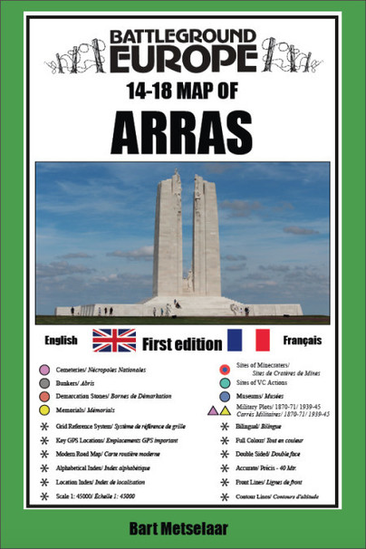
For many years the Holts have provided tourers to the battlefields with excellent practical mapping for the Ypres Salient and the Somme. This map of the Arras area, following the publication of Verdun in this series of Battleground Europe maps, fills one of the gaps in the coverage of the Western Front.
This map of the Arras battlefield is in the same style, using a colour coded system to distinguish the different types of features. It includes over 200 locations of memorials, cemeteries, significant remnants of the battle terrain, remaining fortifications, trenches, and other vestiges of the war. It provides locations associated with many personalities, including VC winners and of the site of mine craters (some of which still exist) in the Vimy area.
The front line at key stages of the war is clearly indicated
GPS references are given for the more signifiant sites. Roads and major tracks are shown. High ground that was of importance in the fighting is clearly indicated.
On the reverse there are enlarged sections of parts of the battlefield of notable importance, such as Notre Dame de Lorette, the northern end of Vimy Ridge (associated with the Canadian Corps) and the city of Arras.
The map extends from just north of Notre Dame de Lorette to south of Bullecourt. To the east it includes, for example, Vis en Artois and Haucourt and to the west Ballacourt, Maroeuil and Mont St Eloi.
The map is bi-lingual (in English and French) so far as is practicable and given the constraints of space. The map is of a manageable size, both in a vehicle and when being used outside on the ground.
There are no reviews for this book. Register or Login now and you can be the first to post a review!
About Bart Metselaar
Bart Metselaar has been visiting the battlefields of the Western Front for over twenty years, from his late teens. He has spent much time walking the battlefields of the Western Front and has acquired an encyclopaedic knowledge of the ground and the surviving remnants of the war.
An amateur cartographer, he has produced the mapping for a number of Pen and Sword Battleground Europe books. He has been working on this Verdun map for some years, painstakingly searching out memorials that have been all but forgotten. He is now turning his attention to the Arras battlefield.
More titles by Bart Metselaar
Other titles in Pen & Sword Military...


Pen and Sword Books
About Us | Contact Us | Delivery Information | Privacy Policy | Cookies | Affiliates | Terms and Conditions | Backlist | Mailing List | Reward Scheme | Review Request
© Pen and Sword Books Limited 2026. Registered in England No. 2527258.
Registered Office: 47 Church Street, Barnsley, S70 2AS.